Utility records, surface markings, and geophysical locating are valuable parts of project planning. But when a design decision or excavation activity depends on knowing where a critical utility actually is, a test hole can provide the direct field evidence the team needs.
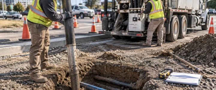
A test hole, sometimes called a pothole or daylighting excavation, is a small, controlled excavation used to expose a buried utility at a selected point. Vacuum excavation is often used because it can remove soil with more control than mechanical digging near known or suspected utilities. Once exposed, the utility can be observed and documented for its horizontal position, approximate depth at that point, size, material appearance, and condition that is visible from the excavation.
Test holes are not needed everywhere. They are most useful where uncertainty creates a meaningful construction, safety, schedule, or design risk. Used at the right locations and early enough in the process, they can help a project team resolve conflicts before equipment, crews, and materials are committed to the work.
Why utility conflicts remain after initial locating
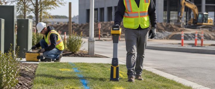
Utility locating and mapping can establish a strong starting picture of subsurface conditions. Electromagnetic locating may trace many conductive lines that can carry a usable signal. Ground penetrating radar may identify some buried features or anomalies under favorable site conditions. Available plans, record drawings, valve boxes, manholes, and other visible features can add important context.
Still, each source has limits. Records may be incomplete or based on older site conditions. A trace may follow a line but not prove its exact depth. Soil conditions, congestion, inactive utilities, nonconductive materials, inaccessible areas, and nearby signal interference can all affect what can be identified from the surface.
Those limitations matter most at conflict points. A line that appears clear of a proposed foundation, trench, bore path, or structure on a plan may be too close in the field. A suspected crossing may be separated vertically, or it may be close enough to require a design change. A test hole replaces assumptions at selected points with direct observation.
What a test hole can confirm
When an excavation is planned and performed appropriately, a test hole can provide information that surface methods alone may not establish with the same confidence. The observations may include:
- The utility’s horizontal position at the exposure point.
- Its depth below the selected reference surface at that location.
- The outside dimensions or diameter that can be safely observed.
- Its apparent material, such as metallic pipe, plastic pipe, concrete, duct bank, or conduit, when visible.
- The number and arrangement of visible conduits or utilities in a crossing area.
- Whether a facility is abandoned, active-looking, damaged, encased, or otherwise unusual, when those conditions are visible.
- Field conditions that affect construction access, such as rock, pavement thickness, groundwater, or dense utility congestion.
These findings should be documented carefully. A single exposure describes conditions at one point, not the entire route of a utility. Pipes and conduits can slope, bend, change depth, or transition through a different configuration between test holes. Project teams should avoid treating one pothole as proof of conditions hundreds of feet away.
When test holes are worth considering
The best time to consider test holes is before final design decisions, procurement, or excavation sequencing has made changes expensive. They are especially useful when a project has a specific decision that cannot be made responsibly with available records and surface-level information.
Proposed utility crossings
New water, sewer, electric, gas, communications, and drainage work often has to cross existing facilities. A test hole can help establish whether the planned crossing has workable vertical and horizontal clearance. It can also identify whether the existing facility is a single line, a duct bank, or a more complex group of conduits than records suggest.
Foundation, structure, and retaining-wall locations
Deep foundations, spread footings, retaining walls, elevator pits, and other structural elements can encounter utilities that are not obvious from surface evidence. Exposing critical lines near proposed structural work helps the design and construction teams evaluate whether a relocation, protection measure, or revised layout may be necessary.
Trenchless installation paths
Horizontal directional drilling, jack-and-bore, pipe ramming, and other trenchless methods require a clear understanding of nearby utilities along the planned path. Test holes are often placed at crossings, entry and exit areas, changes in alignment, and other high-consequence locations. They do not eliminate the need for a project-specific safety plan or appropriate monitoring during installation, but they improve the information available for planning.
Congested urban or institutional sites
Hospitals, campuses, industrial facilities, city streets, and older commercial properties may have many layers of active and abandoned infrastructure. A marked line can be only one part of the subsurface picture. Strategic test holes can help distinguish between separate utilities and clarify the physical arrangement where space is limited.
Unknown depth near excavation limits
When planned excavation approaches a utility with uncertain depth, the issue is not simply whether a line is present. The team needs to know whether the planned cut, grade change, or excavation support system could affect it. Test holes can provide field data to support a safer excavation approach and more realistic production planning.
Prioritizing test hole locations
It is rarely practical or necessary to expose every marked utility. Instead, prioritize locations where the consequences of being wrong are greatest. A useful planning discussion includes the designer, contractor, utility investigation provider, and facility representative when appropriate.
Start by identifying the proposed work limits and the utilities that could affect them. Then rank potential test hole locations based on risk. High-priority locations commonly include:
- Points where proposed work crosses a known or suspected utility.
- Locations where a utility appears to conflict with a foundation, trench, vault, pole, or drainage structure.
- Areas with multiple marks, uncertain records, or conflicting information from different sources.
- Places where an outage, release, service interruption, or public safety impact would have serious consequences.
- Transitions in grade, utility alignment, or construction method.
- Areas where the contractor needs verified information to select equipment or sequence work.
This process turns test holes into a targeted risk-reduction tool rather than an afterthought. It also helps the team explain why each exposure is being requested and what decision it is intended to support.
How test holes fit into subsurface utility engineering
Test holes are commonly used as part of a broader subsurface utility engineering, or SUE, process. SUE brings together records research, field investigation, utility designation, survey, conflict analysis, and data management to improve the reliability of utility information used in design and construction.
ASCE 38 is widely referenced for describing the quality of utility information. In general terms, Quality Level D relies on existing records and oral recollections. Quality Level C adds visible surface features and survey correlation. Quality Level B uses surface geophysical methods to identify the horizontal position of many detectable utilities. Quality Level A uses test holes to obtain precise horizontal and vertical information at specific exposure points.
Quality Level A is not a claim that every utility across an entire site has been fully defined. It is a direct observation at selected locations. The practical value comes from applying that higher-confidence information where it matters most, such as a proposed crossing or a critical conflict.
Planning a productive test-hole program
A good test-hole effort starts with a defined purpose. Before fieldwork begins, the project team should identify what needs to be confirmed, which utilities are involved, and how the results will be used.
Provide the right project information
Share current design drawings, available utility plans, proposed grades, excavation limits, boring paths, and known site constraints. Even preliminary information is useful if it clearly shows the current design intent. The field team also needs to understand access restrictions, pavement restoration requirements, traffic control needs, security procedures, work-hour limits, and any facility coordination requirements.
Coordinate notifications and site access
Required utility notifications and site-specific coordination should be addressed before excavation. Public utility responses, private utility investigation, owner permissions, and traffic or right-of-way requirements can involve different parties depending on the project. The project team should confirm responsibilities early rather than assuming one notification process covers all facilities on site.
Use appropriate excavation methods
Vacuum excavation commonly uses air or water to loosen soil while a vacuum system removes the spoil. The most appropriate method depends on soil, weather, utility type, site restoration needs, spoil handling, and the project’s procedures. Regardless of the method, crews should use controlled excavation practices and follow the applicable safety requirements and owner rules.
Mechanical excavation may be used outside the immediate utility tolerance area when appropriate, but it should not be treated as a substitute for careful utility exposure near a critical facility. The exact approach should be planned around the site conditions and the known or suspected utility hazards.
Document results in a usable format
Test-hole results are most valuable when they reach the people making decisions. Documentation may include utility identification information when known, coordinates tied to the project control, surface elevation, exposed utility elevation, measurements, photographs, field sketches, and notes about conditions observed.
Survey control and a clear reference datum are important. A depth written in a field note is less useful if the design team cannot relate it to proposed grades and structures. The deliverable should clearly state what was exposed, where it was exposed, and any limits on the observation.
Common mistakes to avoid
Waiting until the crew is ready to dig
Emergency potholing during active construction may be unavoidable in some situations, but it creates pressure. Access may be limited, design changes may be harder to make, and equipment or crews may be waiting. Investigating priority conflicts during design or preconstruction gives the team more options.
Testing only the easiest locations
A test hole in an open landscape area may be simple to perform, but it may not answer the question at the actual conflict point. The program should focus on decision-critical locations while still accounting for safe access and practical site constraints.
Assuming surface marks are excavation limits
Surface markings communicate important information, but they are not physical barriers and may not show every line. Marks can be offset, utilities can change alignment, and multiple facilities can share a corridor. Treat the marks and supporting data as part of the investigation, not as a guarantee of clear ground.
Failing to revisit the design after results arrive
The purpose of test holes is to inform a decision. Once results are available, compare them with the proposed work. The next step may be a revised alignment, modified elevation, protection plan, additional investigation, or adjusted construction sequence. If the data is filed but not reviewed, its value is lost.
Using the results to reduce excavation risk
Verified utility information supports better decisions, but it does not remove all underground risk. Additional unknown or unmarked facilities may still exist, and conditions can differ between exposure points. Construction teams should continue to use required notifications, site-specific safety practices, careful excavation methods, and ongoing communication as work progresses.
Still, a well-planned test-hole program can change the quality of a project conversation. Instead of debating whether a utility might be in the way, the team can assess documented field conditions at the points that matter. That can support more reliable design coordination, realistic schedules, safer excavation planning, and fewer avoidable surprises.
Plan critical utility exposures before they become field problems
For projects across Pennsylvania, New Jersey, Delaware, Maryland, New York, and the Washington, D.C. to New York City corridor, Visionary Subsurface Solutions can help teams plan and perform targeted utility investigations, including private utility locating, SUE support, vacuum excavation, and test holes. Contact Visionary Subsurface Solutions to discuss the utility questions affecting your design or upcoming excavation work.